Wednesday, February 16, 2011

East Kameng

The East Kameng district is located in Arunachal PradeshIndia. It shares an international border with Tibet in the north, a state border with Assam and district borders with West KamengPapumpare and Kurung Kumey, who bifurcated from Lower Subansiri on April 1 2000. Under the Chinese sovereignty claim, East Kameng would fall under the jurisdiction of Cuona of Shannan Prefecture of the Tibet Autonomous Region.


Geography

Like West Kameng, the East Kameng climate ranges from arid in the tundra of the north through a cool temperate climate to a humid subtropical climate in the southern sub-himalayan hills bordering Assam.

Economy

Most tribes practise a form of slash and burn agriculture known as Jhum. After clearing the land, crops like barley and rice are planted, and fruit trees are planted to make orchards. Fishing activities first started between 1965-66 and gained momentum in November 1980, when the Fishery Department first started functioning independently. As of today, the Fishery development activities are headed by a District Fishery Development Officer, who was originally the Superintendent of Fisheries. However, this department was understaffed. Funds were also given for rural agriculture and Paddy-cum-Fish Culture activities.
With the advancement of modern technology, horticulture based on apples and oranges is becoming increasingly popular. Today, temperate and sub-tropical fruits are planted in orchards with chemical fertilizers.

People

East Kameng is inhabited by various tribes of similar origin but with distinct cultures and beliefs, practising the Donyi-Polo religion. The most populous of these, the Nishi, are scattered throughout the entire district. Other tribes, especially the MijiSulung and the Aka, are found in regions near the Kameng river.
Since independence, much of the population has relocated to the district capital, Seppa. With the coming of modernism, festivals such as the Sarok of the Aka, Nyokum of the Nishi, Jonglam-Ponklam and Chindang of the Miji and the Gumkum-Gumpa are celebrated in full flair in Seppa.

Koro

The Koro is a Tibeto-Burman language spoken by approximately 800–1200 people in the East Kameng district who live among the Aka (Hruso), but their language is distantly related, with distinct words for basic vocabulary.[1][2] Although it has resemblances to Tani further to the east, it appears to be a separate branch of Tibeto-Burman.[3] Koro is unlike any language in the various branches of the Tibeto-Burman family.[4] Researchers hypothesize it may have originated from a group of people enslaved and brought to the area.[5]
Koro was recognized as a separate language in 2010 by a linguistic team of David Harrison, Gregory Anderson, and Ganesh Murmu while documenting two Hruso languages (Aka and Miji) as part ofNational Geographic's "Enduring Voices" project.[1] It was apparently noticed by earlier researchers.

History

The area around the Kameng river has at various times come under the control and influence of the Mon kingdomsTibet and the Ahom kingdomAka and Nishi chiefs would exert control over the area whenever no major political powers dominated the area.
The Kameng Frontier Division was renamed as the Kameng District. The Political Officer was also redesignated as the Deputy Commissioner of Kameng. However, for political reasons, the Kameng district was bifurcated between East Kameng and West Kameng on June 1, 1980.

Tourism

East Kameng has some tourist attractions. One of these is the Pakhui Tiger Reserve, with a wide range of wildlife. Seppa, the capital, hosts beautiful tribal dance festivals that adds color to the natural landscape. The Himalayas can be viewed from the hill stations of Bameng, Chayangtajo and Pakke-Kessang.


East Kameng
—  district  —
Seppa
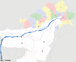
Location of East Kameng in India
Coordinates27°21′00″N 93°2′44″ECoordinates27°21′00″N 93°2′44″E
Country India
StateArunachal Pradesh
CapitalSeppa
Population
• Density
57,179 (2004)
• 14 /km2 (36 /sq mi)
Literacy40.7%% 
Time zoneIST (UTC+5:30)
Area4,134 square kilometres (1,596 sq mi)

Dibang Valley


The Dibang Valley is a district of Arunachal Pradesh[1] named after the Dibang River[2] or the Talon as the Idus call it. The river originates in the mountains of China and flows through the length of the valley which is named after it. The major population of this district consist of the Adis (padams) and the idus. The capital of this district: Anini, is the northernmost district capital in Northeast India. In fact this district contains the northernmost point of Northeast India.
The Idus have a story narrating the first journeys undertaken in course of migration. The story conveys names and location of the Cheethu-Huluni or the twelve rivers that the Idu people came over in the region and settled around. The first accounts of the Idus or the Mishmis as the Ahoms called them are found in the narrations given by the neighbouring Ahoms. The Mishmis inhabited the deep jungles of what is now the Dibang valley.
The district has been divided further into lower and upper Dibang Valley for administrative convenience. The headquarters of the two districts are Roing[3] and Anini respectively. Roing is a newborn town in the plains of the Mishmi hills. It is a beautiful place with picturesque nature and beautiful climate. However Anini is a hilly place lying in the mountains close to the frontiers of China.

At a Glance

The Lower Dibang Valley district, with the its headquarter at Roing is the youngest of the fifteen districts of Arunachal Pradesh. It forms a part of eastern Arunachal Pradesh. It is named after the River Dibang-one of the important tributaries of mighty Brahmaputra. The district is bounded on the north by the Dibang Valley district, on the East by the Lohit district and Mc Mohan Line, on the west by the eastern and Upper Siang districts of Arunachal Pradesh and on the south by the Tinsukia district of Assam. 
The district rises from the Himalayan foothills to the middle ranges with the highest point of Mayudia at a height of 2655 meters from mean sea level. Snow-capped peaks, turbulent rivers, mystic valleys and abundance of rich flora & fauna are a few attraction of the district. The district is well known for its largest cover of thick green forest with almost 80% of the area being notified as reserved forest, wild life sanctuaries or unclassified state forests. 
Lower Dibang Valley Map

The Dibang, Ithun, Ason, Chipu, Aba, Iphi, Sisiri, Datung, Deopani river systems nourish this area making it a lovely place. 
The abundance of natural beauty…..colorful and charming tribes…..ancient archeological sites make the place a perfect destination for nature lovers, adventurous tourists, archeologists and anthropologists……
Sub-Division
Circle
Year of Opening
Rank of Officer In charge.
Roing
Roing
1951
DC/EAC/CO

Dambuk
1954
SDO

Koronu
2000
CO
Hunli
Hunli
1987
SDO

Desali
1959
CO
Dambuk
Dambuk
1954
SDO

Paglam
2002
CO
          (a)  Administrative Sub-Division        :         3(Three) nos.
          
(b)  Administrative Circle                   :         6(Six)     nos.
          
(c)  Police Station                              :         3(Three) nos.
          
(d)  W.T. Station                                :         3(Three) nos.
            (a) Police Station                               :         3(Three) nos.
          
(b) Police Outpost                              :         2(Two) nos.
          
(c) Police Checkgate                          :         2(Two) nos.          (d) W.T. Net                                       :         3(Three) nos.
          
(e) Fire Station                                  :         1(One) no.
          
(f) Strength of Police Personnel
              (including BN)                               :         262 nos.

 Area                                                            : 3900 sq. km 
 Boundary
                      : In North              : Dibang Valley District.
                                      
: In North-East      
China . Assam .
Altitude                          : Roing HQ.          390 mtrs.
Total population as per Census 2001         :         50,438
                                      (a) Male                :         27,173
                                      
(b) Female            :         23,265
Density of Population per sq. km                :         13
Sex ratio Female per 1000 Male                         856
Decennial growth rate (1991-2001)                    41.38  
Literacy rate (Percentage)      :              
          60.34
                  (a)     Male            :                69.2 
                  (b)    Female         :           49.73
Total Rural population (Provisional):
                                      (a) Total person     :         40,332
                                      
(b) Male person    :         21,437
         
                             (c) Female person :         18,895
 Total Urban Population:
                                      (a) Total person     :         10,106
                                      
(b) Male person    :           5,736
         
                             (c) Female person :           4,370
Rainfall:
          (a) Total Annual Rainfall 
               during 2001-2002 at Roing          
:         3418.80 mm.
          (b) Average number of rainy days
               at Roing                                        
:         170 days.
No. of town                                                  :         01 (Roing).
No. of Sub-Division                                     :         03
No. of Circles                                              :         06
No. of Villages                                             :         127
No. of CD Block                                          :         03
  Educational/Training Institution:
Colleges                                                              00
Higher Secondary School                                   03
Secondary School                                               05
Middle School                                                     13
Primary School                                                   25
Pre-Primary School                                             02
Middle School (Private)                                       01
Primary School (Private)                                      05
Central School                                                    01
Vivekanada Kendra Vidyalaya                            01
Jawahar Navodaya Vidyalaya                              01
Industrial Training Institute                       :         01
A.P. Forest Training School                                 01
Dist. Institute for Educational Training               01
Industrial Training Institute, Roing
Name of Indigenous Tribes:   
(a)   Idu-Mishmis   
                   
Idu Mishmi

(b)
  
Adi
                        
Adi
(c)   Mishings
                   
Mishings
(d)  Galo 
                        
Galo
Main Festivals:  
Festivals Collage(a) Reh   (2nd February)
(b) Solung (1st September)  
(c) Ke-Meh-Ha (24th September)
(d) Ali-Aa-Ligang (2nd February)
(e) Mopin (5th April)  
 Important Rivers:
1)     Dibang   
2)
     
Deopani  3)     Iphi-pani   
4)
     
Eze   
5)
     
Diphu Nallah   
6)
     
Abha-pani  
Local rope way to cross river
7)     Dotung   
8)
     
Sisiri  
Road and Communication:
   Total length of Road (in kms):  
(a) APPWD                  :         245.98 
(b) RWD                      :             5.44
(c) 
Forest                   :           50.56
(d) BRTF (BRO)
          :         118.75
Bridge
   Bus Routes Operated by APSTS, Roing and Private Transport Services:  
     (a)   Roing – Tezu   
(b)
  
Roing – Sadiaghat   
(c)
   
Roing – Hunli   
(d)
  
Roing – Dello   
(e)
   
Roing – Rukmo   
(f)
     
Roing – Koronu   
(g)
   
Roing – Chidu   
(h)
  
Roing – Old Abali   
(i)
     
Roing – Balek   
(j)
     
Roing – Tinsukia   
(k)
  
Roing – Anini (Tata Sumo)   
(l)
     
Dambuk - Paglam
Nearest Railway Station: 

              Tinsukia                            113 kms (Approx.)
  Nearest Airport:  
    1)     Chabua                                 138 kms (Approx.) 
    
2)     Mohanbari(Dibrugarh)  :         148 kms (Approx.) 
    
3)     Guwahati                      :         500 kms (Approx.)
 Helipads:  
1)     Roing.   
2)     Dambuk.   
3)
     
Hunli.  
 Main Agricultural Products:
     1)     Paddy   
2)
     
Maize   
3)
     
Mustard   
4)
     
Millet  
 Main Horticultural Products:
     1)     Orange   
2)
     
Banana   
3)
     
Ginger   
4)
     
Pears   
5)
     
Pineapple   
6)
     
Papaya  
 Medical & Public Health:  
District Hospital                          01
Community Health Centre
         01 
Primary Health Centre 
              04 
Health Sub-Centre 
                    11 
Health Unit 
                                01
Dispensaries 
                              02
Homeopathy Dispensaries  : 
        02 
Leprosy Unit 
                              02

Circle wise Data 
Circle
No. of Village
Male
Female
Total
Main tribes
Distance fromRoingkms.
Roing

  • Rural
  • Urban


45
-


13,065
5,736


11,448
4,370


24,513
10,106
Idu-Mishmi and Adi-Padam
00
Koronu
11
1,872
1,652
3,524
Idu-Mishmis
21
Total ROING
Sub-Divn.
56
20,673
17,470
38,143


Dambuk
10
2,809
2,471
5,280
Adi-Padam
45
Paglam
08
2,692
2,471
5,163
Mishing, Adi-padam and Galo
105
Total DAMBUK Sub-Divn.
18
5,501
4,942
10,443


Hunli
28
583
447
1,030
Idu-Mishmis
90
Desali
25
416
406
822
Idu-Mishmis
110
Total HUNLI Sub-Divn.
53
999
853
1,852